Beaches along Big Sur are very different from the
sandy, surfer-enticing waves found on southern California’s coast. For
starters, some can be hard to find or access, but when you get there, you’ll
realize—as we did during our April visit-- they are worth the effort.
Rather than a vision of fun in the sun and splashing among curling waves, early
morning may see fog hugging the coastline. Big Sur beaches can be cool even in
summer, so don’t forget a jacket. And bring sturdy shoes since reaching the
beach might require a hike from the parking area.
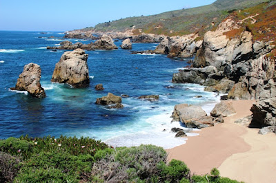 |
| Garrapata State Park in Big Sur |
Garrapata
Beach: Located in Garrapata State Park—the only free park
along Highway 1—the beach in the southern part of this 3,000-acre park is
reached from trails leading down to the coast. With no headquarters or parking
lot, we parked our car beside the highway and walked along a path to the ocean.
It was lined with compact white flowers and other colorful blossoms in April, and
it’s not uncommon to see artists with their easels capturing this gorgeous
sight on canvas. This beautiful combination of water, rocks, surf, and blue
skies attracts people for beach activities, even though the water is not really
swimming temperature.
SandDollar Beach: The largest unbroken stretch of sand in
Big Sur, this crescent-shaped beach is protected from wind by large bluffs, so
the weather is milder. One of the few accessible beaches in southern Big Sur,
it is located 14 miles north of the San Luis Obispo County line. That means it
was a fairly long drive from our hotel in Carmel.
An inclined path and 99 steps on a well-built
stairway lead to down to the beach. A plethora of rocks at the southern end of
the beach entice gem-hunters looking for jade and serpentine. Beachcombers scan
the sand for washed-up sand dollars when the tide is out (we didn’t find any),
and surfers often find this a good place to hang ten.
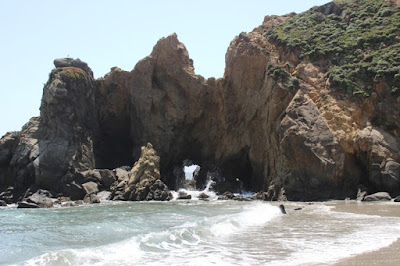 |
| Stunning rock formations at Pfeiffer Beach in Big Sur |
PfeifferBeach: Hard to find
on first try, stunning scenery makes this Big Sur’s most popular coastal access
point. To find this beach, managed by the U.S. Forest Service, we had to locate
the unmarked Sycamore Canyon Road. Hint: It’s the only paved, ungated road west
of Highway 1 between Big Sur post office and Pfeiffer Big Sur State Park. After
we found it, we turn sharply and followed the narrow, winding road for two
miles. At the end was a large parking area and a short path to the beach.
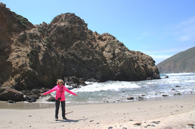 |
| Feeling the wind at Pfeiffer Beach in Big Sur |
Cliffs tower above this breathtaking stretch of
purple-tinted sand, and a large arch-shaped rock formation called Keyhole Rock
just off shore makes for spectacular photo opportunities, especially at sunset.
At low tide people can wade through the water to observe surrounding tide
pools. Covered by towering,
vegetation-heavy bluffs and striking rock formations, the beach’s expansive
shoreline feels secluded from so many
people streaming down Highway 1. Despite a cold, powerful wind blowing during
our April visit, we spent an hour mesmerized by water crashing against the
rocks.
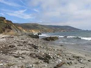 |
Beach at Andrew Molera State Park is smooth in some sections
and rocky in others. At times the sand has a purple tint, too. |
Andrew
Molera Beach: Although we stopped at Andrew MoleraState Park, 23 miles south of Carmel, we did not walk the scenic, mile-long
path to the sheltered beach. The path meanders through a meadow filled with
wildflowers and sycamore trees and provides fine views of the coastal mountain
range to the east. The path parallels Big Sur River, which enters the sea
adjacent to Molera’s beach. A bridge covers the river in summer, but otherwise
you’ll have to wade across the cold water. Take a picnic and enjoy watching
surfers or horse-back riders in the park.
Photos by Larry and Beverly Burmeier and free sources


No comments:
Post a Comment