Sunday, December 27, 2020

True nature of Colorado Bend State Park in Texas

Towering rock canyons, more than 350 caves, and two spring-fed creeks make Colorado BendState Park near San Saba, Texas, a fabulous place to explore. With 16 miles of hiking trails, including 14 miles suitable for mountain biking, the park provides plenty of opportunities to enjoy unspoiled nature.

Go swimming in a beautiful spring-fed creek.

It’s about two hours’ drive from Austin (four hours from Dallas), making this a doable day trip or weekend getaway (both time and budget wise) if you’re visiting the Texas Hill Country. If you love the outdoors, the park is a great discovery filled with lush and scenic river trails and sparkling Gorman Falls.

 If the landscape isn’t enticing enough—and it certainly should be—there are multiple recreational opportunities. Whether your favorite outdoor activities include birding, fishing, hiking, picnicking, camping, or photography, you’ll find plenty to do at Colorado Bend State Park--just be sure to check on availability as long as COVID restrictions are in place.

Hike along the Colorado
River in the park.
Located along six miles of Colorado River frontage, Colorado Bend is a large state park, covering 5,328 acres. Partly because of its size, the intent is to keep it natural and easy to care for. Primitive tent camping is allowed in 38 numbered sites, and there are two backpack areas where guests can pitch tents. No electricity is available, but when serenity and peacefulness take over, you won’t miss it. Pets are allowed as long as they are kept on a leash no longer than six feet.

Originally an old Indian camp, the site near Gorman Falls is protected for archeological study. During the 1950s-1970s that area was a fishing camp and RV park. The state bought the land in 1984, adding more land from the former Lemons Ranch in 1987. These areas were combined and opened to the public as Colorado Bend State Park in 1988. Still, only 40,000 visitors per year journey the 18 miles from San Saba, through the tiny town of Bend, and over gravel roads to reach the park.

Native pecans, ferns, and cacti grow abundantly in the park, and wildflowers sprout up in the spring. Wildlife includes coyotes, bobcats, and mountain lions—although you probably won’t encounter these species. White-tail deer, armadillos, and squirrels are more common sights. You might also see wild turkeys, endangered golden-cheeked warblers, black-capped vireos, red-tailed hawks, and eagles (they nest on canyon walls).

Several geological features in the park are unique to this region. Spicewood Springs is a popular hiking trail with numerous creek crossings that leads to a refreshing water hole where visitors often come to picnic and swim. Painted rock formations, colored by different minerals seeping through, add to the beauty of this spot.
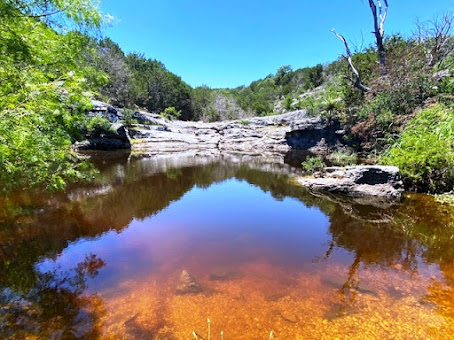
Springs along the trails add to the natural beauty of the park. 

Staff will take visitors on a two-hour guided tour to spectacular Gorman Falls on the western bank of the Colorado River, approximately 10 miles above Lake Buchanan (check that these tours are happening during the pandemic). Participants drive their own vehicles behind the guide for approximately seven miles from park headquarters. Then they hike to the base of the falls, a moderate one and a half mile round-trip that becomes slightly more difficult over rocky terrain the last 40-50 yards.

Gorman Falls is a highlight
of any visit to the park.

This impressive spring-fed 60-foot-high waterfall, tumbles over a cliff and mists ferns and other vegetation as it descends. Comprised of travertine, the top layers of calcium deposits are extremely fragile, so the area is protected. From the viewing deck, watch the flowing falls and then turn around to see the Colorado River meandering on the opposite side.  

You can also hike to Gorman Falls on your own, and guided cave tours are available during non-pandemic times. Outdoor enthusiasts are free to explore more trails and enjoy the park on its own primitive terms.

Some trails can be challenging, 
especially in hot Texas summers.

March and April are busy months--that’s prime time for white bass fishing and birding (214 species of birds have been identified in the park). Wildflowers start blooming in the spring, and the weather is fine for camping or hiking. There are so many ways to appreciate nature in Colorado Bend State Park that your first visit won’t be your last.

Photos by Larry and Beverly Burmeier


Sunday, December 20, 2020

What can a travel insurance policy do for you?

 During the past year we have heard much about the importance of travel insurance. Although it does add expense to your trip, it can reimburse you for many out-of-pocket expenses if you or a travel companion becomes ill or has an accident. 

Most policies also cover trip delay, trip interruption, lost baggage or baggage delay, flight delays, and much more. (Check for COVID coverage, as that may not be covered)

In addition, there are many services you might not be aware that having a travel insurance policy could
entitle you to. Need help planning your trip or booking guides and tours? Want to reserve a tee time at your destination or purchase tickets for a special event? Lost your eyeglasses or run out of a prescription and need a replacement? Many plans include a concierge service that can assist you with such things.


Although these are non-insurance services, knowing assistance is available can help make travel easier. The graphic below outlines some of the most common tasks that may be available to you through your policy. Make the most of what you've paid for! 


Information courtesy of Travel Insured International, a Crum & Forster Company. I do not receive any compensation from the company for posting this information.

Sunday, December 13, 2020

Hike Devil's Bridge in Sedona

Stunning red rock formations surrounding Sedona, Arizona are a calling card for visitors. You could hike a different trail every day for a month and still be impressed by the awesome beauty of the region.

Red limestone formations create amazing scenery around Sedona, Arizona

If you enjoy exploring on foot (yes, you can enjoy the scenery from a car, jeep, or helicopter too), one of the must-do hikes is Devil’sBridge Trail. It’s a moderate out-and-back trail just a 15-minute drive from town in the Coconino National Forest. If you access the trail via the most popular trailhead on Dry Creek Road, the hike will be a little more than four miles with an elevation gain of 400 feet.

Devil's Bridge as seen from the air.

One afternoon during our first visit to Sedona we took a helicopter ride to view well-known (and fondly named) sandstone rock formations just outside the city. We flew over Devil’s Bridge—and decided right then to go there as soon as we landed. That put us at the parking lot at mid-afternoon.

Our turn to take the hike

My advice: Go early in the morning when parking spots are still available. Because it was so crowded, our hike was a mile longer each way than it might have been. Jeeps and vehicles with four-wheel drive can venture part way on the rough dirt road, possibly cutting hiking time in half depending on where you are able to park. We walked the entire long and dusty route on Dry Creek Road.

The path is very rocky in places.

After about 1.3 miles (it seems much longer) you’ll see the path leading up the red cliffs to the bridge. The trail becomes rockier and steeper for almost another mile—scrambling over boulder is what makes the hike moderate rather than easy.

If you want to climb onto the bridge, take the right fork that leads to the top. It’s steep and a little more challenging, so Larry opted to stay where he was to take pictures of me as I walked over the bridge. He had a stunning view of the entire natural rock bridge, while I continued climbing to access the sandstone bridge from one end.

Beverly heads to the steep path that accesses the bridge.

The view from the top is breathtaking, but don’t forget to watch where you are walking. The bridge is very narrow at its midpoint, and the surface is uneven. It can be especially dangerous if wet from rain or a high wind is blowing. I don’t advise sitting down with feet dangling over the edge, as we saw one young boy doing.

Beverly walks on Devil's Bridge.

If you're not afraid of heights, it's a remarkable adventure that I recommend. Take enough time to soak in the outstanding landscape all around. 


View of the bridge from the opposite direction.

After you’ve admired views of surrounding red rock formations and tried to spot those you recognize by name, it’s time to scramble back down to Dry Creek Road and walk the rutted path back to the parking lot. To park, you'll need to purchase and display a Red Rock Pass for $5.

Allow about two hours for this popular hike, if for no other reason than to say you really did it!

Photos by Larry and Beverly Burmeiere

Sunday, December 6, 2020

Autumn hiking in Breckenridge, Colorado

Golden aspens glitter in the sunlight as we hike around Cataract Lake in Colorado. It’s late September, and aspen trees are reaching their peak of gorgeousness. Massive displays capture nature’s beauty while we repeatedly “ooh” and “ah” at the brilliant foliage displays.

Beautiful fall foliage set against majestic
mountains and blue skies in Breckenridge

One stop on this Colorado visit is to Breckenridge. With perfect blue skies and towering mountain peaks in the background, we think autumn is the most beautiful time of year here. It’s also a great time to take advantage of warm-weather activities like hiking, biking, golfing, and fishing.

Of course, when you plan a trip in advance, you can’t predict weather and fall foliage peaks, so we feel very lucky that our timing has worked out so well. Every place we visit around Breckenridge has proved spectacular, and the days have been mild and sunny.

Reflections along Sawmill Creek Trail

Breckenridge lies at the base of the Rocky Mountains in Summit County, Colorado. While its ski trails have made it a popular resort town for skiers in winter, outdoor enthusiasts can find plenty to do in any season of year. The only drawback for some people might be the elevation. The town sits just below 10,000 feet, which means oxygen levels are lower than at sea level. We find it necessary to slow our pace when hiking but otherwise seem to adjust okay.

Cataract Lake in the sunshine
Hikes most people can do

If you want to be outdoors enjoying the beauty of the area but don’t feel up to challenging mountain hike, here are a few that are doable for most activity levels.

Sawmill Creek Trail: This is an easily accessible mile and a half round trip trail that starts near the downtown Main Street shopping area. Parts of the trail can also be accessed directly from several condos in the vicinity. Aspens reflect in a lovely lake that we walk around.

As we return to the parking lot where our car is, we see the sign for Burro Trail, which is in White River National Forest, and decide to see where it goes. It’s another easy trek surrounded by autumn color. Go as far as you like then return on the same path, just as many local dog-walkers do.

Golden aspens all around the trail 


Cataract Lake:
Our original destination was Lily Pad Lake, but we find it closed when we arrive at the trailhead. Instead we hike Cataract Lake, about an hour’s drive north of Breckenridge. Located in the Eagles Wilderness area in the White River National Forest, this hike is now one of our favorites. Sunshine glowing through the aspens is simply spectacular as we walk a 2.3 mile loop around the lake. Spotting a bald eagle in a tree is a bonus.

On the way back to Breckenridge, we stop at Sapphire Point and take the 0.8 mile loop for scenic views of Lake Dillon, a favorite boating spot. It’s a nice place for a picnic and only about 8 miles north of Breckenridge.

View of Dillon Lake from Sapphire Point
McCullough Gulch: After a few days to acclimate to the high elevation, we decide to tackle a moderate hike (as opposed to easy hike). McCullough Gulch is 5.4 miles round trip. Since it is out-and-back, you can go as far as you want and then return along the same path. Be sure to drive two miles on the dirt McCullough Gulch Road/ No. 851to get closer to the gate and the entrance to the trail. 

Hiking on McCullough Gulch trail
This one is a little more challenging, and we find our walking sticks helpful for navigating over the uneven surface of large rocks and tree roots. Flowing streams, cascades, majestic mountain scenery, and more golden aspens make the hike worthwhile.

More outdoor options: Be sure to spend a little time walking along BlueLake within the town center. For more views drive eight miles south of Breckenridge to Blue Lakes Road/ No. 850 and park at the dam at Upper Blue Lake. From here you can view a waterfall, and you might even see some mountain goats. If you prefer exploring on two wheels, there are plenty of bike paths in and around Breckenridge--and rental businesses to outfit you with the proper style of bicycle for your adventures.

Photos by Larry and Beverly Burmeier