 |
| Stroll through Zion on several easy walks. |
Arriving at
Zion National Park on a September afternoon, my
husband Larry and I were awed by the distinct redness of sheer cliffs that
frame the valleys of Zion.
Anxious to
start exploring in Utah’s first national park (established in 1919) we
immediately set out to see the Emerald Pools, since the trailhead was near our
accommodations at the Zion Lodge. We quickly learned that the beauty of Zion is
enhanced by its accessibility.
Throughout these magnificent landscapes visitors can find a
mix of trails to suit every ability level, from paved, wheel-chair accessible
strolls to challenging rock climbs for skilled adventurers. The following guide
starts with easy paths and ends with the breathtaking hike to Angel’s Landing.
 |
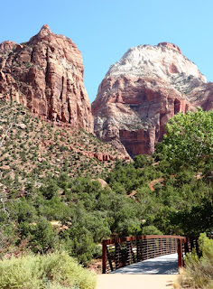
| Pa'rus Tral is doable for all abilities and offers some of the most spectacular sights. |
Pa’rus: Allow at
least an hour for an early morning or evening stroll. The path provides great
views of soaring canyon walls and Zion’s famous sandstone formations, Count of
Patriarchs (try to get all three peaks in one photo) and Great White Throne.
Named for Old Testament figures Abraham, Isaac, and Jacob, the cliffs that form
the Patriarchs are among the most recognizable landmarks.
You don’t have to walk the entire two miles. Stop at the
Visitors Center to rest and learn about history and geology of the park, Then take
the shuttle to explore more of the canyon. Pa’rus is the only trail in the park
that is wheelchair accessible and also open to bicycles and pets.
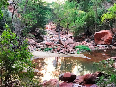 |
| Emerald Pools is a great family hike. |
Emerald Pools:
The Lower Pool trail is only 0.6 miles one way, so it’s a comfortable walk, and
you can continue on to the Middle Pool. During our most recent visit in 2019,
the Upper Pool was closed because a rock slide had obliterated the path.
Trickling waterfalls, especially after a
rain, emerald-green water, and wildflowers in spring and summer attract
visitors to this family-friendly trail. But, as always, the incredible rock
formations that distinguish Zion are the main attraction.
 |
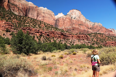
| Riverside Walk is also doable for most guests. |
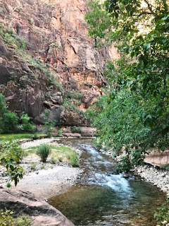
Riverside Walk:
In a park filled with deep canyons and soaring cliffs, this level paved path is
understandably one of the most popular. Starting from the Temple of Sinawava
the two-mile round trip meanders along the Virgin River to the bottom of a
narrow canyon. Along the way, look up to admire 2,000-foot tall rock walls and
Zion’s hanging gardens. Moisture from numerous springs allows swampy plants to
grow right out of the sandstone.
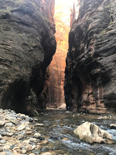 |
| Try The Narrows if you love adventure. |
The Narrows: At
the end of Riverside Trail, you might be tempted, as I was, to wade through the
river for a taste of Zion Narrows. The trail sloshes through water into a slot
canyon less than 30 feet wide in places and flanked by towering sandstone
palisades. A sand bar here and there gave me respite from the current and
strenuous activity of wading in thigh deep water. Smooth canyon walls covered
in vertical striations of brown, tan, and beige dwarfed me but drew me further
into The Narrows, but eventually I returned to my starting point.
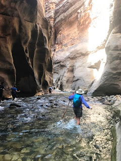 |
The Narrows is a hike through the Virgin
River in Zion National Park. |
If you want to try river hiking bring sturdy shoes and
walking sticks because the rocks and boulders are slippery, and it’s easy to
lose your balance. You can rent special
river-hiking boots and walking sticks from outfitters in Springdale and
experience a downstream half-day trip. At places the sheer canyon walls are so
narrow that sunlight rarely penetrates--lending a mysterious feel to the
adventure.
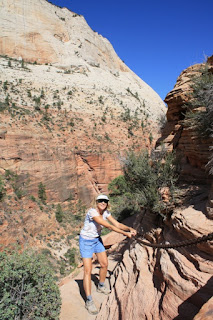
West Rim Trail to
Angel’s Landing: If you want to try a challenging hike in Zion, this is it.
Characterized by 21 closely-spaced switchbacks called Walter’s Wiggles, the
trail leads upwards to spectacular views of Zion Canyon below.
Start early in the morning, and allow about
five hours, more if you want time to soak in the magnificent views—and allow
time to rest a bit before starting back down.
 |
| A more challenging trail to Angel's Landing features many switchbacks. |
Take the shuttle to The Grotto where you’ll pick up the
trail. Elevation here is 4300 feet, and you’ll gain almost 1500 feet climbing
rugged slopes on the five-mile round-trip journey.
The approach to Angel’s Landing, a
sheer-walled monolith 1500 feet above the North Fork of the Virgin River,
follows a steep, narrow ridge.
During
this last half mile, footing is tenuous, but chains aid your ascent on narrow
precipices. Despite numerous warning signs the climb is reasonably safe in good
weather if you have sufficient leg and upper body strength—and no fear of
heights.
 |
| Hang on if you climb to the summit. |
Even if you opt out of the summit approach you’ll still
enjoy amazing views along the four-mile round-trip. Although the trail is
graded, it provides a good workout as you climb uphill through a cool canyon,
navigate the switchbacks, and reach Scout Lookout, the turn-around point. The
hike provides a bounty of breathtaking views--sheer red walls, myriad geologic
patterns carved in rock, caves formed by overhanging ledges, and a cool river
flowing through the canyon bottom.
Photos by Larry and Beverly Burmeier


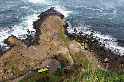
 Another legend,
possibly influenced by identical basalt columns (part of the same ancient lava
flow) across the sea in Scotland, says that Fionn's wife, Oonagh, disguised Fionn as a baby and tucked him in a cradle. When Benandonner saw the size of
the 'baby', he assumed that its father, Fionn, must be an enormous giant. He
fled back to Scotland in fright, destroying the causeway behind him so that Fionn would be unable to chase him down.
Another legend,
possibly influenced by identical basalt columns (part of the same ancient lava
flow) across the sea in Scotland, says that Fionn's wife, Oonagh, disguised Fionn as a baby and tucked him in a cradle. When Benandonner saw the size of
the 'baby', he assumed that its father, Fionn, must be an enormous giant. He
fled back to Scotland in fright, destroying the causeway behind him so that Fionn would be unable to chase him down.