Wednesday, July 31, 2013

Early isolation of Tasmania is evident in its history


Town square in Hobart, Tasmania
Our cruise ship docked in Hobart, the capital of Tasmania and second oldest capital in Australia. Hobart is nestled between Mt. Wellington, Mt. Nelson, and the Derwent River. A land bridge connected Tasmania to mainland Australia 10,000 years ago, but sea levels rose and land masses drifted, forming an island. Isolated by the Southern Ocean, Bass Strait, and Tasman Sea, rough seas discourage passage. As a result, the Aboriginal people were separated from European settlers in the early 19th century. When British arrived, they fenced Aboriginal lands and conflicts resulted. Today, no full-blooded Aborigines remain, but many people have Aboriginal heritage.

The city’s history can be traced to 1803 when a small party of soldiers and convicts, under command of Lt. John Bowen, was dispatched from Sydney to establish a penal colony. Originally the town was located on the eastern bank of the Derwent, but later it moved to Sullivan’s Cove on the western shore, which is the current center of Hobart’s waterfront area.
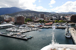
View of Hobart's harbor
Geographically, Tasmania is closer to the equator than the South Pole. It’s a relatively small island and easy to explore on foot. There’s a water view from almost everywhere in Tasmania since there are thousands of lakes, even inland—some manmade for hydroelectric power and others natural from glaciers. No spot is more than 90 miles from the ocean.

Only 129,000 people call Hobart their home town, and only 500,000 inhabit Tasmania, which is about the size of West Virginia. It’s composed of the main island, just four kilometers off the shore of Victoria, Australia, and 300 offshore islands. The eastern shore is warmer and has less rain than the western side because of Mt. Wellington, which is a cloud magnet. Interestingly, Tasmania sits on Austral-Asia Plate, so it is stable and doesn’t have earthquakes.
Many well-preserved historical buildings, monuments, and cottages are still in use, primarily for government services. Try your luck at Australia’s first legal casino in Hobart.
Kangaroos roam freely in Bonorong Wildlife Park
Known for outdoor adventure, visitors can participate in the Tahune Airwalk, whitewater rafting (Franklin, Huon, and Picton Rivers), or surfing big waves. Cheese farms in the north; vineyards, lush green valleys, tranquil forests, and a former penal colony are other attractions. Pick your hike: coastal terrain or mountains.

At Bonorong Wildlife Park, we had the opportunity to see a variety of animals such as kangaroos, Tasmanian devils, and wallabies. An Aboriginal word meaning “place of shelter” Bonorong started as a rescue center in the 1980s, a mission it still fulfills as well as education and tourism. Kangaroos roam freely in open space, and buckets of food are scattered around. Follow the staff’s advice to pet under the neck between the front legs, not on top of head, and you might get that dream photo.


Don't mess with Tasmanian devils!
We learned the Tasmanian devil’s bite is very strong, eight times that of a pit bull, and the ugly nocturnal animals emit blood-curdling screams that frightened early settlers.
One of the staff cuddled a cute koala bear and another held a large, soft wombat--more fun picture opportunities.

Koalas are cute and cuddly but not too social.

Later, on the way to Richmond, a small town known for its rather plain and stoic Georgian architecture of the early 1800s, we took the Brighton Bypass on the banks of the Jordan River. When Aboriginal artifacts of trade and stone tools dating back 30,000 years were found, the design of the bridge was changed to preserve these artifacts.
Ancient bridge in Richmond, Tasmania
St. John's Catholic Church in Richmond
Fifty-five structures from the Colonial era are still in Richmond, including a bridge built in 1823 and jail (gaol) that later became an outpost. St. John’s Catholic Church, which dates from the 1820s, is the oldest church still in use for services in Australia. Because the historic past is actively preserved  towns like Richmond are popular destinations in Tasmania.

Photos by Larry and Beverly Burmeier

Read more travel stories at Striped Pot and Austin Adventure Travel


Sunday, July 28, 2013

More healthy spine tips for air travelers


Avoid aches and pains when traveling by air.
Frequent travelers can prevent backaches, stiff necks, and overall soreness by steering clear of some classic mistakes. Don’t pack too much, skip the stylish shoes for traipsing through airports, and don’t plan more activity than your body is used to.

Since some of the best opportunities to hurt your back and neck happen when traveling by air, here are tips to keep your spine healthy:

Lighten your load.

Before you even get into a cramped airplane seat, you face a bigger hazard: luggage. Pack as lightly as you can manage. Take advantage of curbside check-in if available, so you don't have to haul the bags yourself. A few bucks as a tip to keep your back healthy? Priceless.
Plan what you pack to take less.

Balance your load.

When you carry bags, try to balance the load -- a roller in one hand, your hand luggage in the other. On long walks through airports, trade sides regularly. If you have a suitcase with wheels, load everything on it and push, don't pull it. Pushing keeps the weight in front of you centrally, giving you better control.

Fly in comfort.

Onboard the plane, place a neck pillow or rolled-up blanket behind your neck to support it so the headrest isn't pushing your head forward. Do the same behind your lower back to support the lumbar spine. If you can, use your carry-on like a footstool to raise your knees above the level of your hips. For reading, pull out the tray and place a pillow or your rolled-up jacket on it, then put your reading material on top so you don't have to bend your neck down to read.

Circulate this.

Never aim the airplane fan to blow directly on your neck -- it can cool down your neck muscles and cause spasms and neck pain later. Circulate the air around you; don't point it on you. Same with the fan in the hotel.

Have some pillow talk.


If you have a favorite pillow and can afford the luggage space, bring it along because hotel pillows are notoriously awful. If the hotel only has big pillows and you're a back sleeper, beat the thing silly or try to move some of the fiber around to make a dip for your head. Your goal with pillows is to keep your neck in a neutral position that's similar to when you are standing or looking straight ahead.
This is a good pillow, but if you don't have one that supports the
 neck like this, try to create your own from what is available.

Repurpose the towels.

Improvise your own perfect pillow using a towel from the bathroom and folding it to look like a wedge-shaped cervical pillow -- the thicker part of the wedge goes under your neck, the thinner part under your head. Or simply roll up a towel, put it behind your neck, and sleep on a pillow thick enough to keep your ears in line with your shoulders on the big pillow. The idea is to support your neck so it's in alignment with your spine, not bent forward.

This guest post is by chiropractor, Dr. Jay Lipoff, CFT, (www.backatyourbest.com), author of Back at Your Best: Balancing the Demands of Life with the Needs of Your Body (www.BAYBBook.com).
Photos from free photo sites.


Wednesday, July 24, 2013

Bike the Paul Bunyon Trail through northern Minnesota


Many cities, especially in northern states, have taken old railroad beds and turned them into recreational trails suitable for traveling on foot, bike, roller blades, or skateboards.  One of the most prominent Rails to Trails projects is the Paul BunyanTrail in the northern woods region of Minnesota.
Flowers line the paved Paul Bunyan Trail in Minnesota.


Bikes or rollerblades can be rented for summer trips, ands nowmobiling is a favorite winter activity along the trail. Since we didn’t have our own, we rented bicycles to scope out the scenery.

The Paul Bunyan Trail is the longest  Bike trail in Minnesota at 112-miles. It connects the Heartland Trail, the Blue Ox Trail and the Cuyuna State Trail.. With the paving of the 19-mile segment from Guthrie south through Laporte toward Walker, completed in 2010, the Paul Bunyan Trail now yields a continuously paved trail from Brainerd  to Lake Bemidji State Park.
A long trail, you can ride any portion or all of it.

The terrain of the Paul Bunyan Trail ranges from flat and open to hilly and scenic—and we experienced both on our journey. Along the trail there are many areas to stop and rest and enjoy nature in Northern Minnesota.  Typical distance between the 14 connected towns is six to nine miles, so you can easily find a place to stop and eat or rest awhile. In summer, you might even take a dip in any of the numerous lakes that the Trail parallels.

Starting from Pequot Lake, we followed a relatively level route along the highway. On the other side were meadows filled with purple flowers waving in the breeze. After a couple of miles the landscape opened up, and we could see Gull Lake as we rode toward the town of Nisswa. Piers and boats indicated that this was a popular vacation area. Lovely lake views contrasted with stands of pine, fir, birch, maple, and other trees that lined the trail.
Gull Lake provides a refreshing scene along the way.

In Nisswa, we stopped for a brief rest near the Visitor Information Center. With temperatures in the upper 80s and plenty of humidity after two days of rain, we needed a hydration break. A bright green railroad car, antique machines, and a blue cow caught our attention, so we went across the street to check them out.
This blue cow welcomes visitors to the town of Nisswa along the trail.

If we had continued, we could ride all the way to Brainerd. Instead, we took a hilly path on back roads to Grand View Lodge, where we were staying. We learned to pump up bike speed prior to approaching each hill—to get a running start on the incline. Coasting down was the reward. It was challenging enough for a good ride but not so difficult that a casual rider couldn’t enjoy the activity and scenery.

For a longer journey or family vacation, you could pitch a tent and camp at designated areas along the way. For those who prefer more comforts, the tree-lined trail is in the heart of resort country—check out resorts and hotels along the Paul Bunyan Trail.

Photos by Beverly Burmeier

Tuesday, July 23, 2013

Sail the 7 Seas with Royal Caribbean


If you're after a cruise holiday with a difference, look no further than Royal Caribbean International. You've seen them on TV with their fabulous onboard activities and beautiful destinations. The company has an innovative fleet of ships featuring some of the most boredom-busting activities you could imagine. There’s plenty of entertainment for little ones as well as grown-ups.

For example, Oasis of the Seas has been described as the "ultimate" cruise holiday ship--a vast floating village. It has seven 'neighborhoods' which each carry different themes, outdoor parks and green spaces, and a Dreamworks Experience to delight all ages. Hailed as the ship that revolutionized cruising, Oasis of the Seas is home to some of the most exciting sights and sounds you'll ever experience on a ship , including an AquaTheatre complete with acrobats, the first amphitheatre at sea.

Oasis has two FlowRider surf simulators, rock-climbing walls, a zip line that's a lofty 9-decks high, a full-sized basketball court, mini-golf and even its own ice skating rink.

Kids will love its high-octane sporting facilities, and on top of that, there are stacks of child-friendly activities. There's a Youth Zone, an unforgettable DreamWorks Experience featuring the chance to meet characters like Shrek and Kung Fu Panda, a 3D movie theatre and more. The ship's dedicated kids' teams organize daily activities for children of all ages, with clubs like Royal Babies, Royal Tots, a Nursery, teen lounge areas and teen discos.

A trip on Oasis of the Seas is an experience you won't soon forget.

This post is sponsored by Cruise Thomas Cook. You can search cruises online and compare various itineraries, sailing dates and ports of call to help you find your perfect cruise escape.
 
 
Photos by Larry and Beverly Burmeier


Saturday, July 20, 2013

Enjoy nature in Belize


While on a cruise in the Western Caribbean, Larry and I booked a snorkeling excursion at Belize. The speed boat from Chukka Tour Company picked us up from the Crown Princess and went directly to our snorkeling spot, 25 minutes from the ship. After stopping briefly at Goff’s Caye for people to get snorkeling gear (we had our own), the boat headed out to the reef.
Many varieties of coral are found at the Belize Reef.

First time snorkelers, accompanied by several guides, got off in shallower water, but within the first few minutes two people decided this wasn’t for them.
Experienced snorkelers/strong swimmers are taken further out to the edge of the reef. We jump over the side of the boat into pleasantly cool water. Coral in many different shapes and sizes is scattered; colors are muted.

Belize consists of hundreds of islands and the largest barrier reef in the Western Hemisphere.  The Belize Barrier, which runs for 560 miles along the Atlantic, is second in the world (the Great Barrier Reef of Australia is the largest). Only an estimated 10 percent of the sea creatures around it have been classified. To prevent damage to the reef, cruise ships must anchor miles offshore and tender visitors to land.
 the water, waves splashing over our bodies.  Swimming against the current back to the taxi boat was a bit more challenging.
With our snorkel masks on, we view fish darting around: Yellow with white stripes, blue iridescent, small black, tiny yellow, white and gray, and long, skinny needle fish. Star fish resemble large spiders with long tentacles. For 45 minutes we float, swim, observe, and enjoy being in the ocean.
Larry takes pictures of fish and coral.

Once everyone was on board, the boat sped back to the island for relaxation time. Rum punch flowed freely, and food was available for purchase, although we had brought our own snacks. The sandy beach led to a rocky shoreline. Quintensential palm trees gave the small island a lovely tropical feel, so we enjoyed the restorative ambience of our Belize retreat.
Almost half of Belize is protected habitat. This makes for a variety of nature excursions where visitors can explore caves, rivers, and rainforests with exotic tropical flora and fauna.  The jungle is home to 570 bird and orchid species. Temperatures fluctuate from the mid 70s to mid 90s year-round.

We soon realize that Belize has three distinct worlds, each appealing to a different kind of tourist: traditional touring and shopping venues; activities like ziplining, cave tubing, and horsebackriding; and water sports for divers, snorkelers, kayakers, and surfers. You can take trolley tour across the oldest swing bridge in Central America and the only manually operated swing bridge in the world that’s still functioning.
  In 1862, it became a British Crown Colony and part of Jamaica. British Honduras became Belize in 1973 and gained independence in 1981. Belize is the northernmost Central American nation and the only one where English is the official language.
Goff's Caye has palm trees and a sandy beach.
Although Mayans occupied the country 5,000 years ago, shipwrecked English seamen founded the first settlement in 1638.

Hurricanes have been the bane of Belize. A storm in 1931 destroyed two-thirds of the structures and killed more than 1,000 people. Hurricanes in 1955, 1961, and others since have caused millions of dollars in damage. Still, there are plenty of ways to enjoy this relatively unspoiled environment, which is why it’s a favorite port for cruise ships.
Photos by Larry and Beverly Burmeier

Monday, July 8, 2013

Victoria Falls is called "Smoke That Thunders"


Victoria Falls in August, between wet and dry seasons

We see a roaring wall of water almost a mile wide plummeting 400 feet into deep gorges. Very quickly we understand why Victoria Falls is considered one of the most spectacular natural wonders of the world. Its unusual form allows visitors to view virtually the entire width of the Falls face-on, making an incredible sight not duplicated anywhere else in the world.

Straddling the border of Zambia and Zimbabwe in Africa, Victoria Falls is the largest sheet of falling water in the world. Although Scottish explorer and missionary David Ligingston was the first Westerner to view the Falls in 1855, it had been home for 3 million years to many African tribes, who gave it the name Mosi-oa-Tunya, the Smoke that Thunders.
Rainbows are incredibly bright from sunlight on the mist
It’s a fitting description because during the end of the December to April rainy season, the spray coming off the rock wall is so heavy that it obscures the curtain of water, and it’s impossible to see the foot of the falls in the Zambezi River below. But this iridescent mist makes for incredibly bright and colorful rainbows in the sunlit sky.

Immense amounts of water flow over the
rock walls of Victoria Falls.
Approaching Victoria Falls through the park’s tropical foliage-covered paths, we quickly feel the humidity and hear the ominous roar of water. Mist billows up above the trees during our mid-August visit, spraying people walking on established paths. Expecting to get wet while at the various overlooks, we're wearing rain ponchos to keep our clothes and cameras as dry as possible.
 
In the dry summer season, from September to November, the flow slows with the result that the cascade resembles dozens of separate waterfalls. But that’s the best time to view the entire scope of the Falls and get a sense of its magnitude. It’s easy to see the rocky face of the cliffs and depth of the gorges during the dry season.


Victoria Falls National Park is a UNESCO World Heritage Site, protected by both Zambia and Zimbabwe governments. A bridge over the Zambezi River connects the two countries, and you might get to see bungee jumpers take a death-defying leap of 300 + feet off the bridge--just listen for the blood-curdling screams!.
 
If possible, try to view the Falls from both countries, although you may need different visas to get these vantage points. Also view the Falls both morning and night for different perspectives--you might even see a “moonbow” in the evening.
Bridge between Zambia and Zimbabwe,
just where white water rafting begins


If you’re really adventurous, go rafting down the Zambezi River, the most challenging white water trip you can imagine. During our experience, we maneuvered through several class 5 rapids (getting totally submerged and soaked), and portaged around one class 6 (the highest rating).

You can also take a helicopter tour or Flight of Angels, a ride in a fixed wing Cessna, for fabulous overhead vistas of the Falls and river upstream.  Fishing, horseback riding, and elephant safaris are among other excursions that will provide unforgettable experiences and great wildlife spotting opportunities.


Expect to get wet as the spray blows onto walking paths.
Relax at day’s end on a two-hour Zambizi River sunset cruise, including drinks and hors d'oeuvres. The river is calm and full of birds and hippos (and crocodiles) submerged like submarines with just their eyes above water. Sunsets are incredibly red and simply spectacular.
Gorgeous sunsets on the Zambezi River.

Victoria Falls is easily accessible from all major destinations in Africa, and accommodations are readily available, even resorts from which you can walk in minutes to the Falls.

The magic of thundering water, soaking mist, and deep, sheer gorges is simply awe-inspiring, and it’s no wonder Victoria Falls is one of Africa’s most popular tourist attractions.

Photos by Larry and Beverly Burmeier

Read more travel stories at Striped Pot and Austin Adventure Travel


Wednesday, July 3, 2013

Get face-to-face with wildlife at Tasmania's Bonorong Wildlife Park


Started as a sanctuary, Bonorong now welcomes tourists
to educate them about Australia's indigenous wildlife.
I’m wandering in a large open field, camera in one hand and brown pellets of kangaroo food in the other. Very soon I have the opportunity to use both. Kangaroos roam freely at Bonorong Wildlife Park in Tasmania, and the food is too enticing to avoid the humans who offer it.  That means I get to practice a new skill:  Pet kangaroos under the neck between the front legs, not on top of head.
I learn to pet the kangaroo the right way.
So I get personal with a couple of marsupials and snap dozens of photos. They get full bellies—buckets of ‘roo food are readily available--before it’s time to escape from human attention and switch places with other kangaroos who have been enjoying peace and quiet in a separate area.

Tasmania seemed like the best destination on our Australia cruise to see and learn about various indigenous wildlife. Although the park started as a wildlife rescue center during the 1980s, it now focuses more on education and tourism. But kindness to the animals is still a big part of its mission; after all, Bonorong is an Aboriginal word meaning “place of shelter.”
After the kangaroo encounter, I follow an established path around the park, stopping to take pictures of other animals, including many birds, some in cages and others roaming freely. I see wallabies, blue-tongue lizards, wombats, and Tasmanian devils.  I stroke the soft fur of a koala bear held by a staff member and try to get a shot of its face.

Tasmanian devils, now found in the wild only on this island, scamper around their pen in a frenzy of constant motion. Other devils are sleeping, not unusual since these are nocturnal animals, although it makes them appear docile when they are not. The bite of a Tasmanian devil  is very strong—eight times that of a pit bull. Even more, the blood-curdling screams of this carnivorous animal can make your hair stand on end—just as they frightened early settlers. Best advice: Don’t pet!
 
Tasmanian devil is an ominous creature--with a well-deserved
reputation for being frightening.
After roaming among the wildlife at Bonorong, we head along into Hobart on Brighton Bypass on the banks of the Jordan River.  During its construction, artifacts of trade and stone tools of Aboriginals from 30,000 years ago were found, so the design of the bridge was changed to preserve these artifacts. Although no full-blooded Aborigines remain today, many peoplehere  have an Aboriginal heritage.

We head to Richmond, a popular tourist destination, where we admire 55 buildings from the Colonial era that were built in the Georgian architecture style dating to the early 1800s—rather plain and stoic with little adornment. The town later became an outpost, with these buildings becoming additional modern-day attractions.
Koalas are cuddly and cute but easily spooked.
They can also be quite large.
After taking pictures of a bridge built in 1823, the jail (gaol), and St. John’s Catholic Church, the oldest church still in use for services in Australia, we walk across the village green back to town. No wildlife here, but at least I had the Australian experience of petting a koala and a wombat at Bonorong.
Photos by Larry and Beverly Burmeier
Read more travel stories at Striped Pot and
Austin Adventure Travel.


Monday, July 1, 2013

Tasmania's rough and tumble reputation belies its natural attractions


 When our cruise ship docked in Hobart, the capital of Tasmania and second oldest capital in Australia, we entered a deep water harbor nestled between Mt. Wellingotn, Mt. Nelson, and the Derwent River.

Once connected to the Australian mainland, land masses drifted as sea levels rose around 10,000 years ago, and an island about the size of West Virginia was formed. Located just four kilometers from Victoria, Australia, Tasmania is composed of the main island and 300 offshore islands.
The harbor at Hobart, Tasmania
There’s a water view from almost everywhere on the island; no spot is more than 90 miles from the ocean. Thousands of lakes, even inland (some manmade for hydroelectric power and others natural from glaciers), are scattered throughout Tasmania, adding to its reputation as an excellent place for outdoor adventure.

On shore, looking back to the Princess ship
Because getting to the island is made difficult by the Southern Ocean, Bass Strait, and Tasman Sea (known for its rough passage), the Aboriginal people living on the island were separated from European settlers who arrived on the mainland in the early 19th century. In 1803 a small party of soldiers and convicts, under command of Lt. John Bowen, was dispatched from Sydney, Australia to establish a penal colony—a legacy that many people still associate with Tasmania.

Originally, the town was located on the eastern bank of the Derwent River (warmer and drier than the western section), but eventually it moved to Sullivan’s Cove on the western shore, which is the current center of Hobart’s waterfront area. Fortunately, Tasmania sits on the Austral-Asia Plate, which makes it stable and free from earthquakes. We’re surprised to learn that Tasmania is closer to the equator than to the South Pole.


Lovely water for sailing off the coast of Tasmania
Tasmania is easy to explore on foot, although we covered a significant part of the island in one day on a bus . Visitors have many activity choices such as the Tahune Airwalk; whitewater rafting on Franklin, Huon, and Picton Rivers; and surfing big waves. Cheese farms in the north; vineyards in lush green valleys; and tranquil forests entice visitors to explore the island’s topography that ranges from coastal to mountainous. Seals, penquins, and quirky Tasmanian devils (found in the wild only on this island) are examples of various wildlife found on the island.


The Square in Hobart's business district
Going through Hobart, we passed the Royal Tasmanian Botanical Gardens and crossed the Derwent River on a bridge opened in 1965 but destroyed in 1975. An additional bridge, Bowen Bridge was built later. At Rosny Point we enjoyed spectacular overviews of the city and harbor.

Red flowers bloom on the New Zealand
Christmas tree during our December
visit.
Later, Larry and I walked around Hobart admiring the inviting square, well-preserved historical buildings, monuments, and cottages that are still in use, primarily for government services. Another attraction (we didn’t indulge) is the first legal casino in Australia. Tasmania has much to attract visitors, and I’ll tell more about our excursion there in another post.

Photos by Larry and Beverly Burmeier