 |
| California's Big Sur coastline is one stunning picture after another. |
 |
| Stunning scenery marks the Big Sur coast |
Our visit to Carmel, California, provided the
perfect opportunity for exploring the Big Sur coastline. Located along California
Scenic Highway One 150 miles south of San Francisco, this region has been
called “The greatest meeting of land and sea.”
Indeed, it has beaches, mountains, forests, and
valleys. All this scenic geography melds into natural grandeur along the coast.
Outdoor enthusiasts often think this is as close to heaven as you can get. Winters
are mild due to closeness of the Pacific Ocean, while coastal fog cools summer
mornings. But the fog lifts by early afternoon, and there is plenty of sunshine
year round.
 |
| Hiking in Big Sur State Park |
We like to hike as well as enjoy spectacular beauty
of the landscape while driving, so this seemed an excellent choice for a
week-long trip. With our home base at
Hyatt Carmel Highlands, we found plenty to explore along this designated
American National Scenic Byway.
Here are some highlights from our visit last spring:
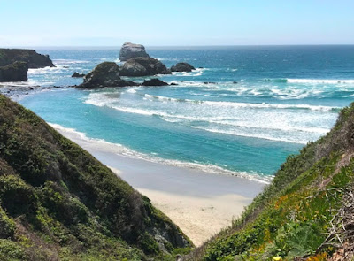
Pfeiffer Big Sur State Park: As we left our resort to drive to this park,
fog on the ocean and mountains kept temperatures cool. Ocean swells splashed
against rocks up to 20 feet in the air. Spring flowers like blue lupine, orange
poppies (state flower), white calla lilies, and so many varieties of red, pink,
yellow, and white flowers grew near the shore, on rocky slopes, and grassy
meadows. In other words, springtime was blooming everywhere.
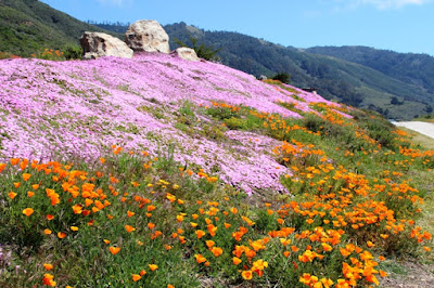 |
| Spring wildflowers are simply gorgeous. |
Lovely rolling
hills dotted the landscape with bright green pastures while cedar trees clumped
with wide, intertwining branches. Ancient redwoods thrive along a very narrow
strip of Big Sur in this vicinity.
 |
| Starting the hike |
We hiked uphill on Valley View Trail for views of
the landscape below. The return was easier, of course, after which we enjoyed a
picnic lunch in the park area before walking the Nature Trail and River Trail,
both short and easy. Big Sur River runs through the park, which is further
inland, so it doesn’t offer the same stunning ocean views as oceanside parks.
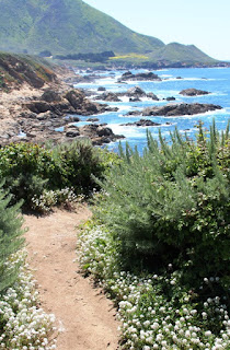 |
Trail to the beach at Garrapata
State Park in Big Sur |
GarrapataState Park: Highway One passes within the borders of
this free park situated between the base of St. Lucia Mountains and the rugged
Pacific coastline. This large park
overflows with trails highlighting its diverse landscape. Five main
marked trails, four of which are grouped together in a loop going into the
mountain range, provide opportunities for hiking and backpacking. We walked to
the beach on a path lined with tiny white flowers, crossed a scenic bridge, and thoroughly enjoyed wandering in this lovely park.
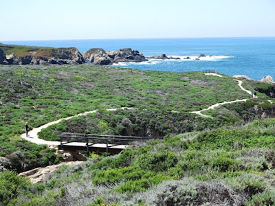 |
| Overview of the beach trail at Garrapapta State Park |
BixbyBridge: Construction of this dramatic bridge allowed travel
more easily along the coast, especially when Highway 1 was completed in 1937.
Stunning views are worth stopping for as the bridge arches over the gorge where
Bixby Creek flows and empties into the sea. From the north side of the bridge
we could get photos of ocean and land—cliffs, bridge, and road heading up the
mountain. Views from the south side after crossing the bridge were more
expansive.
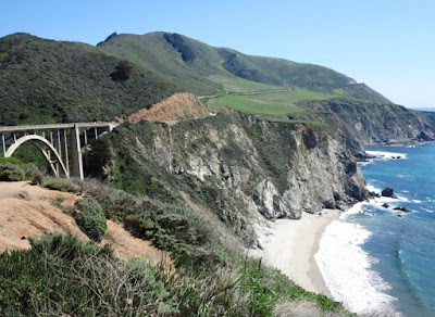 |
| Famous Bixby Bridge with views of water, sand, cliffs, and mountains |
JuliaPfeiffer Burns State Park: Named for one of Big Sur’s most
beloved pioneers, this park features seven marked trails. One popular trail
leads to McWay Falls. Driving to the park the highway climbed nearly 1,000 feet
above sea level, and Overlook Trail to see the falls descends for a closer look
at McWay Cove and the falls below (after traversing cliffs high above the
ocean). At the overlook, we saw a creek that finishes its short journey in
dramatic fashion forming 80-foot McWay Falls which plunges directly into the
ocean.
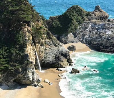 |
| McWay Waterfall at Julia Pfeiffer Burns State Park along Big Sur |
 |
| Navigating logs to cross Limekiln River |
LimekilnState Park: One of the smallest state parks in Big
Sur, it is often overlooked by visitors driving along Highway One. The park got
its name from the limestone business that thrived there in the late 17th
century.
Limekiln was also the site of a thrilling waterfall
hike for Larry and me. To reach the waterfall we had to cross Limekiln River
three times each way—and not by bridge. Logs strewn across the river in a
hodge-podge manner provided our only option for getting across—not so easy as
the logs shifted with the moving water and our own ability to balance was
sometimes questionable.
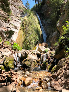 |
| The waterfall at the end of our hike |
But we managed to stay dry—unlike other hikers we
witnessed who got wet and cold when a foot slipped. So we agreed the trek to
the stunning 100-foot waterfall was worth the challenge.


1 comment:
I haven’t done this road trip since the ‘90s. Your recent blog reminds me that I need to do it again! It’s a gorgeous trip alongside the Pacific Ocean.
Post a Comment